


|
|||
|
Discover the origin of the ‘Aquae Patavinae’ and the history of the Euganean thermal area...
|
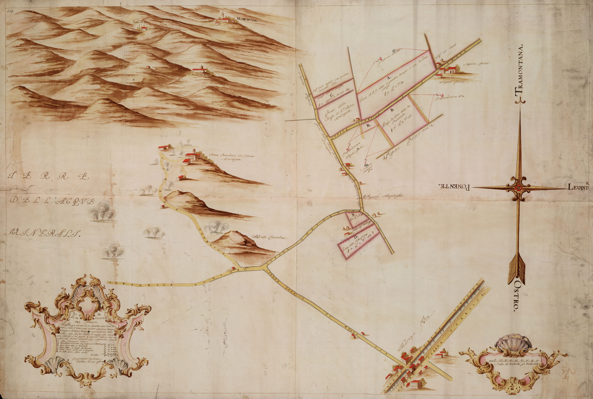
Cartographic dossier n°3Giorgio Fossati, ALCUNE PEZZE DI TERRA ESISTENTI IN S. PIETRO MONTAGNON, TERRITORIO PADOVANO AMMINISTRATE DALLA VENERANDA SCOLA DI SAN ROCCO DI RAGIONE DELLA COMMISSARIA TODESCHI (14/11/1794)This document reproduces a partial slice of the territory of San Pietro Montagnon, embracing northeast the Euganean Hills and southwest Mezzavia. The express purpose of the map is to represent with a topographical accuracy and a wealth of details the possessions of the Venetian Scuola di San Rocco, located also thanks to the mention of the adjoining properties. The five land parcels («pezze di terra»), marked in the key by letters of the alphabet, report the following definitions: «A: pezza di terra detta li quattro campi ossia Terre Longhe, B: La Piantada, C: il campo del Pozzetto, D: il Frascine, E: un’altra simile»; on the paper, they are painted with a pink watercolour colouring which underlines the boundaries. In the middle of the map, west of the country lane running beside parcels E and D, the author depicts the road which led from Mezzavia to the church of San Pietro Montagnon; this road ran at the foot of Colle Bortolone, perhaps of Monte Castello and finally of a third low hill, defined as “Monte del Prete” in the 1834 map of Pivetta; at the foot of this hill rose the parish church, with two annexed building and other separate edifices. Some pools of hot water are drawn on both sides of the road. La riproduzione della mappa sottostante è stata eseguita dalla Sezione di fotoriproduzione dell’Archivio di Stato di Venezia ed è stata pubblicata con atto di concessione n. 51/2013 e Prot. n. 5802 del 01.08.2014.  Dal Cortivo…  Gran Carta del Padovano della Reale Società delle Scienze e delle Lettere di Gottinga (1781)… |
||
|
|
|||